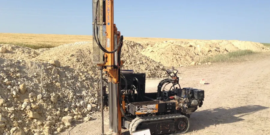
Lowering a single-packer system into a freshly drilled borehole, isolating a test section, and watching the water level drop under constant head—that's how we start most permeability assessments across Wigan. We use both the Lefranc method for granular soils and the Lugeon technique for fractured rock, often within the same investigation campaign. The apparatus is straightforward: a slotted standpipe, a graduated reservoir, and a pressure gauge calibrated to read down to 0.1 m of head. What complicates things locally is the transition between the Pennine Coal Measures sandstone and the overlying glacial till, a contact zone that runs right through parts of Ince-in-Makerfield and Pemberton.
In our experience, a single borehole rarely tells the full story; we typically run three to five test stages per hole to capture vertical variability. The data feeds directly into deep excavation design where groundwater control makes or breaks the construction programme, and into grouting specifications when the mass permeability exceeds the contract threshold.
In Wigan's Coal Measures, a Lugeon value above 5 typically means grouting is inevitable—below 1, and the rock is tighter than many assume.
Process overview
Wigan's geology splits the borough into two distinct permeability regimes, and the contrast between them shapes how we configure every test. West of the River Douglas, around Shevington and Standish, the glacial boulder clay dominates—a stiff, overconsolidated diamicton with sand lenses that can give bulk permeability values anywhere from 1×10⁻⁷ to 1×10⁻⁹ m/s. East of the river, where the Middle Coal Measures outcrop, the sandstone and siltstone layers behave completely differently: secondary fracture permeability can exceed 1×10⁻⁵ m/s in weathered zones near the surface but drop two orders of magnitude within 15 m of depth.
We adapt the test interval length accordingly—longer packs in the till to capture sandier stringers, shorter in the rock to isolate individual fracture sets. The BS 5930 code gives clear guidance on test duration and acceptance criteria, but local interpretation matters when you are dealing with the perched water tables that appear after heavy rain in the Douglas valley. For road schemes and brownfield redevelopment, we often combine these measurements with
CBR road testing to ensure the pavement design accounts for seasonal moisture variation in the subgrade.
Local context
Wigan's industrial past left a legacy that directly affects how groundwater moves beneath the surface today. The town grew rapidly around coal mining and cotton mills in the 19th century, and by 1881 the population had surpassed 48,000—much of that expansion built over unmapped backfilled shafts and colliery spoil. When you put a Lugeon test into ground that might contain old workings, the results can swing from near-zero to full water loss in a single metre of advance. We have seen boreholes near the former Pemberton Colliery site where the apparent permeability jumped by a factor of 50 once the drill bit intersected a collapsed gallery.
Missing this kind of feature during site investigation can lead to sudden inflows during piling or, worse, long-term settlement from groundwater drawdown. The Environment Agency's aquifer designation for the Pennine Middle Coal Measures adds a regulatory layer: if the test shows hydraulic connection to the underlying aquifer, discharge consent conditions may apply. That is why we always run at least one test within the zone of proposed foundation influence, not just at the site boundary.
Quick answers
What is the difference between Lefranc and Lugeon testing?
The Lefranc method is designed for soils and soft rock, measuring permeability through a slotted section of borehole casing under constant or falling head. It is the go-to technique in Wigan's glacial till and alluvial deposits west of the River Douglas. The Lugeon test is specifically for fractured rock—like the Coal Measures sandstone beneath eastern Wigan—and uses a packer to isolate a section of borehole while water is injected at up to five pressure stages. The Lugeon value quantifies fracture conductivity rather than matrix permeability, making it essential for tunnel and dam projects.
How many test intervals do you recommend for a typical Wigan site?
For a standard residential or light commercial site in Wigan, we recommend a minimum of three test intervals per borehole: one within the upper weathered zone (typically 2–5 m deep), one at the proposed foundation level, and one 3–5 m below foundation depth to check for upward hydraulic gradients. In areas with known mining history—such as Pemberton, Ince, or Platt Bridge—we add at least one additional test near the anticipated coal seam depth to identify potential void connectivity.
Does the groundwater in Wigan's old mining areas affect the test results?
Absolutely. The Middle Coal Measures beneath Wigan contain abandoned workings that can act as preferential flow paths, sometimes producing artificially high permeability readings if the borehole intersects a collapsed gallery or fractured roof zone. Conversely, unmined areas of the same formation can be very tight—Lugeon values below 1. We always cross-reference test results with historical mine abandonment plans held by the Coal Authority to interpret anomalous data correctly.
What does a Lefranc or Lugeon permeability test cost in the Wigan area?
In Wigan, a field permeability test programme typically ranges from £480 to £950 per test interval, depending on borehole depth, access conditions, and whether Lefranc or Lugeon methodology is required. A complete site investigation with multiple intervals, mobilisation, and a factual report generally falls within a broader ground investigation budget, which we tailor to the specific project scope and site constraints.
How do you ensure the test results are accepted by building control and the Environment Agency?
All our field permeability tests are conducted under our UKAS-accredited laboratory's quality management system (ISO/IEC 17025), with full traceability of pressure transducers and flow meters calibrated to national standards. Reports are structured to BS 5930:2015 data presentation requirements, including raw pressure/flow tables, steady-state verification plots, and the geological log for each test interval. For Environment Agency submissions, we include aquifer classification and any implications for groundwater control or discharge consenting.