Together, we solve the challenges of tomorrow.
READ MORE →Ground investigation in Wigan forms the essential first phase of any construction or civil engineering project, providing the critical data needed to design safe, stable, and cost-effective foundations. This category encompasses a comprehensive range of intrusive and non-intrusive techniques aimed at characterising the subsurface conditions beneath a site, from soil and rock properties to groundwater behaviour and potential contamination. In a borough like Wigan, with its complex industrial legacy and varied terrain, skipping this step can lead to severe structural failures, costly delays, or environmental liabilities. A robust investigation programme, often beginning with a desk study and progressing to targeted field tests such as the CPT (Cone Penetration Test), allows engineers and developers to de-risk their projects and comply with regulatory requirements from the outset.
The local geology of Wigan is dominated by the Pennine Coal Measures Group, consisting of interbedded sandstones, siltstones, mudstones, and historically significant coal seams. This Carboniferous bedrock is extensively overlain by glacial till and pockets of glaciofluvial sands and gravels deposited during the last ice age, creating a highly variable near-surface environment. The area's deep mining history introduces a critical layer of complexity: unrecorded mine shafts, shallow workings, and zones of collapsed ground known as bell pits are widespread, posing a major subsidence risk. Furthermore, the presence of made ground—uncontrolled fill material from former collieries, ironworks, and textile mills—can contain contaminants and exhibit poor engineering properties, making detailed physical exploration absolutely indispensable for any development.
All ground investigation work in Wigan must adhere to the rigorous framework established by British Standards and relevant UK legislation. The primary technical standard is BS 5930, which provides the code of practice for site investigation, guiding everything from sampling frequency to in-situ testing methodology. For contaminated land assessment, BS 10175 offers the definitive procedures, working in conjunction with the Environmental Protection Act 1990 and the planning regime under the National Planning Policy Framework (NPPF). Developers must demonstrate that land is ‘suitable for use’, which often requires a phased investigation to satisfy the local planning authority, Wigan Council, particularly where a site may be designated as a Special Site of Contaminated Land under Part 2A of the Environmental Protection Act.
The types of projects that demand a thorough ground investigation in Wigan are diverse, ranging from residential extensions and housing estates on former brownfield land to large-scale commercial developments and infrastructure upgrades. Any structure transferring load to the ground—be it a domestic dwelling, a multi-storey apartment block, a warehouse, or a wind turbine—requires a foundation design informed by factual geotechnical data. Road and drainage schemes rely on investigation to assess subgrade strength and aggressive ground conditions, while schools and healthcare facilities must prove environmental safety. Without this critical intelligence, derived from methods like cable percussive boreholes, trial pitting, and in-situ techniques such as the CPT (Cone Penetration Test), projects face the unacceptable risk of unforeseen ground conditions that can multiply budgets and halt construction entirely.
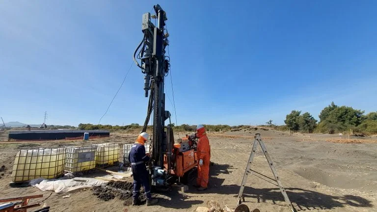
A typical investigation follows a phased approach starting with a desk study of historical maps and geological records to identify mining and contamination risks. This is followed by intrusive fieldwork such as trial pits, boreholes, and in-situ tests like the CPT to assess soil strength. The process concludes with laboratory testing and a factual report that characterises ground conditions for foundation design.
Wigan's history of extensive deep and shallow coal mining means many areas are at risk of subsidence from unrecorded mine shafts and collapsed workings. A mandatory mining risk assessment, often required by the Coal Authority and Wigan Council, integrates historical records with targeted drilling to locate voids and assess ground stability, which is vital for safe foundation design and obtaining planning permission.
BS 5930 is the primary code of practice for site investigation in the UK, setting out the procedures for planning and executing ground exploration. Compliance ensures that the number and depth of exploratory holes, sampling methods, and in-situ testing are appropriate for your site's complexity and the proposed structure, providing legally robust data that satisfies building control and warranty providers.
A contaminated land assessment is typically required as a planning condition for any development on or near a site with a potentially polluting former use, such as a colliery, mill, or landfill. Wigan Council's environmental health department will review a phased investigation under BS 10175 to ensure potential risks to human health and controlled waters are identified and properly remediated before construction begins.
We serve projects across Wigan and surrounding areas.