Retaining wall design across the Wigan borough demands more than a standard solution—it requires precise reconciliation of Eurocode 7 (BS EN 1997-1:2004) with the area’s complex ground profile. The legacy of deep coal mining, which shaped Wigan’s industrial identity through pits like the former Parsonage Colliery, has left a subsurface marked by unrecorded shafts, variable backfill and perched water tables within the Middle Coal Measures. Under BS 8002:2015, every earth-retaining structure must be verified for Ultimate Limit State against sliding, overturning and bearing failure, but in Wigan the real challenge lies in accurately modelling ground–structure interaction where fill depth can exceed 5 metres over glacial till. Our geotechnical team supplements desk-study data with targeted intrusive investigation, often combining in-situ permeability testing to quantify drainage behind the stem and test pits to expose the true contact between made ground and natural Mercia Mudstone, ensuring the design earth pressures reflect site conditions rather than generic assumptions.
In Wigan’s mining-affected ground, a retaining wall design that ignores unrecorded backfill can underestimate active earth pressure by 30 % or more.
Process overview
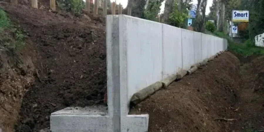
The analytical workflow applied to retaining wall schemes in Wigan relies on limit-equilibrium software paired with soil parameters derived from high-quality ground investigation. Given the prevalence of stiff glacial till over weathered mudstone across the Douglas Valley, design models must capture the effective-stress strength envelope with careful attention to residual friction angles, particularly where relict shear surfaces exist in over-consolidated clays. We routinely specify the drained friction angle from consolidated-undrained triaxial tests with pore-pressure measurement, feeding those values into a
triaxial assessment that defines the Mohr-Coulomb envelope used in the wall analysis. For gravity and cantilever walls founded on the Wigan Coal Measures sandstone, bearing capacity under eccentric load is checked against the in-situ SPT N-value profile, which we often calibrate through
spt-drilling to a depth of at least 1.5 times the retained height. The structural design of reinforced concrete stems, counterforts and bored-pile contiguous walls then follows BS EN 1992-1-1, with durability requirements adjusted for the mild but persistently damp exposure conditions characteristic of Greater Manchester. All deliverables include a Geotechnical Design Report with clear differentiation between drained and undrained parameters, long-term pore-pressure assumptions and a construction-sequence note that accounts for Wigan’s seasonal fluctuation of the shallow drift aquifer.
Local context
With a population approaching 330,000 and a legacy of deep mining extending beneath the town centre, Wigan presents a geotechnical risk profile where wall failure can carry disproportionate consequences. The Coal Authority’s interactive map identifies multiple Development High Risk Areas where unrecorded shafts and adits intersect proposed retaining wall alignments, meaning a desk-based mining report is merely the starting point. The most common failure precursor observed in Greater Manchester earth-retaining structures is the gradual build-up of hydrostatic pressure behind an inadequately drained wall, which can elevate the driving force beyond the design value even when the wall itself is structurally sound. In Wigan this is compounded by the interbedded sandstone and siltstone of the Pennine Middle Coal Measures, where preferential flow paths can concentrate groundwater against the wall backface. A well-documented retaining wall collapse on a brownfield site in nearby Bolton in 2016, triggered by a combination of unanticipated fill thickness and heavy rainfall, underscores the need for rigorous drainage design and seasonal groundwater monitoring, both of which we embed into every Wigan retaining wall design to satisfy the long-term serviceability requirements of BS EN 1997.
Quick answers
What is the typical cost range for retaining wall design on a residential plot in Wigan?
For a typical residential retaining wall up to 2.5 m retained height in the Wigan area, the design fee generally falls between £950 and £3,100, depending on whether the site is within a Coal Authority Development High Risk Area and the complexity of the ground investigation data already available. This covers the Geotechnical Design Report, structural calculations and a drainage schedule compliant with BS 8002.
How does mining legacy in Wigan affect the design of a retaining wall?
Mining legacy introduces the risk of unrecorded shafts, shallow adits and variable backfill thickness that can alter the stiffness and drainage regime behind a retaining wall. The design must incorporate a detailed Coal Authority report, targeted rotary or percussive boreholes to prove competent strata, and often a reinforced base or cantilever wall configuration that can tolerate some differential settlement without loss of serviceability.
Which earth pressure theory do you apply for walls retaining glacial till in the Wigan area?
For the stiff glacial till common in Wigan, we generally adopt drained parameters (c' and φ') and compute earth pressures using the Coulomb wedge method, accounting for wall friction at the soil–structure interface. Where till is fissured or contains sand lenses, we also run an undrained check using total stress parameters from triaxial testing to ensure short-term stability during construction, as required by Eurocode 7.