One of the costliest errors a developer can make in Wigan is assuming uniform ground conditions across a site without verifying the dynamic soil stiffness at depth. The legacy of shallow coal workings, glacial till overlying Coal Measures, and the variable thickness of the weathered zone means that two boreholes 15 metres apart can return fundamentally different shear wave velocity profiles. When a project relies on generic VS30 values derived from regional geology maps rather than site-specific MASW data, the seismic design category can shift enough to trigger expensive foundation redesigns or, worse, an uninsurable structure. We run seismic refraction lines alongside MASW arrays when the bedrock interface is irregular, giving the engineer a complete picture of both velocity layering and rippability before the first cubic metre is excavated.
MASW turns a site classification guess into a defensible Vs30 measurement that stands up to Eurocode 8 scrutiny.
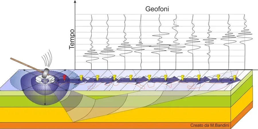
Process overview
A recent project on the eastern side of Wigan illustrates the point. The site sat on what the desk study called “glacial till over mudstone,” yet the MASW dispersion curves revealed a low-velocity lens at 4 to 7 metres depth that correlated with a buried sand channel, something the trial pits had missed because they terminated too shallow. The Vs30 we measured was 195 m/s, placing the site firmly in Eurocode 8 ground type D, whereas the desk-based assumption had been type C. That single finding allowed the structural engineer to adjust the base shear before the frame was detailed, avoiding a six-figure retrospective fix. The array geometry matters in Wigan’s post-industrial setting because ground-borne vibrations from the West Coast Main Line and heavy goods traffic on the A49 can smear the high-frequency portion of the dispersion image if the geophone spacing is not tuned to the expected depth of investigation.
Local context
Ground conditions shift markedly between the Douglas Valley floor and the higher ground around Haigh and Aspull. In the valley, thick alluvial silts and soft clays produce Vs30 values below 180 m/s, pushing sites into ground type D or even E where deep soft deposits exceed 10 m. Up on the sandstone ridges near Haigh Hall, shallow rockhead yields Vs30 above 360 m/s and a type B classification. A developer who commissions a single MASW line in the valley and extrapolates it to a sloping site on the valley shoulder will underestimate the lateral velocity gradient, potentially designing for the wrong seismic class on half the footprint. The Coal Authority’s mining reports flag recorded workings, but they rarely capture the stiffness degradation in the collapsed pillar zones that MASW can identify as velocity inversions at 15 to 25 metres depth.
Quick answers
Why choose MASW over conventional seismic refraction for site classification in Wigan?
Refraction alone can miss low-velocity layers hidden beneath faster strata, a situation common in Wigan where soft glacial deposits sit above sandstone. MASW processes surface-wave dispersion to resolve velocity inversions, giving a more reliable Vs profile and Vs30 value for Eurocode 8 classification.
How much does a MASW survey cost for a typical residential development plot in Wigan?
For a standard single-array MASW survey on a residential plot in the Wigan area, costs range from £1,300 to £2,200 depending on the number of lines, array length, and whether combined refraction is required.
What ground type classifications do you typically find across the Wigan borough?
We encounter everything from type B (Vs30 >360 m/s) on the sandstone outcrops near Haigh to type D (180–360 m/s) across much of the glacial till cover, and type E in the deeper alluvial deposits along the River Douglas corridor.
Can MASW detect old mine workings beneath a site?
MASW does not image voids directly, but it can identify the velocity reduction associated with collapsed workings and destressed rock zones above old roadways, flagging areas where targeted rotary drilling should follow up. We always cross-reference MASW results with Coal Authority mining records.