Wigan sits at roughly 40 metres above sea level on the Lancashire Coal Measures, and that mining history shapes everything we do below ground. The Coal Authority records over 40 shallow mine entries within 5 km of the town centre, many unmarked or poorly backfilled. When a developer near the Leeds and Liverpool Canal needed to confirm the extent of old pillar-and-stall workings beneath a proposed apartment block, we ran a series of vertical electrical soundings across the site. The resistivity contrast between intact sandstone and collapsed, water-filled voids was stark, and the profile mapped a hidden drift entry no historical map showed. In Wigan, resistivity imaging is rarely optional; it is the first step before you even think about placing a borehole. The MASW method often complements the resistivity profiles when we need shear-wave velocity for seismic site class alongside the void detection work.
Resistivity profiles separate dry sandstone from water-filled voids in Wigan's Coal Measures, often with a contrast ratio of 5:1 or more.
Process overview
A job that sticks in mind is a warehouse extension off Wallgate, where the client had trial pits showing stiff clay to 2 metres and assumed competent ground. We ran a dipole-dipole resistivity line across the footprint and found a low-resistivity trough at 6 metres depth trending northeast, consistent with a buried stream channel now filled with soft organic silt. The site investigation budget shifted entirely after that single profile, with targeted
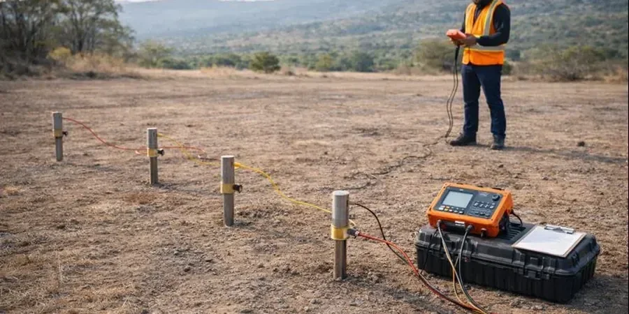
CPT testing pushed into the channel to get continuous tip resistance and pore pressure data, while the surrounding area required only shallow pad footings. That is the power of resistivity in a town built on glacial till over Coal Measures: it tells you where the anomalies are before you mobilise the drill rig. Our field crew uses a Syscal Pro switchbox with 48 electrodes, typically spaced at 2 to 5 metres depending on the target depth, and we process the inversion in Res2DInv the same evening. For sites where the water table is shallow, as it often is near the River Douglas floodplain, we combine resistivity with
in-situ permeability testing to assess drainage and dewatering requirements before earthworks begin.
Local context
The mistake we see repeatedly across the Wigan borough is relying on trial pits alone when the Coal Authority report flags shallow workings. A trial pit stops at 3 to 4 metres; a VES sounding reads to 40 metres. In one case, a contractor excavated for a retaining wall along the A49 and punched through into a bell pit that trial pits had missed by less than two metres laterally. The collapse cost six weeks of downtime and a redesign of the foundation system. Resistivity is a volumetric measurement: it senses lateral and vertical changes in apparent resistivity that point to air-filled or water-filled cavities, fractured rock zones, or buried services. On brownfield sites, particularly former colliery yards, we sometimes detect leachate plumes with resistivities below 5 Ωm, which is a red flag for aggressive ground conditions that attack concrete. If you skip the geophysics and go straight to intrusive investigation, you are gambling that your borehole will hit the anomaly by chance, and in Wigan, with its labyrinth of old workings, that gamble rarely pays off. For sites with suspected mine entries, grouting investigations often follow the resistivity survey to design a proper backfill or consolidation programme.
Quick answers
What depth can a resistivity survey reach on a typical Wigan site?
With a standard 48-electrode layout at 5-metre spacing, a 2D ERT line achieves roughly 40 to 50 metres of investigation depth, which covers the full height of the Middle and Lower Coal Measures in the Wigan area. VES soundings with a maximum current-electrode spread of 200 metres can push beyond 60 metres, sufficient to reach the Millstone Grit beneath the coal sequence. The actual depth of penetration depends on the resistivity of the near-surface layers: conductive clay reduces signal penetration, while dry sandstone or made ground allows deeper current flow.
How much does an electrical resistivity survey cost in Wigan?
For a typical site in the Wigan area, budget between £480 and £950 per survey line, depending on the array length, electrode spacing, and number of soundings. A simple VES sounding with a single spread is at the lower end; a full 2D ERT profile with multiple array configurations and inversion processing sits at the upper end. We provide a fixed-price quote after reviewing the site layout, the target depth, and the Coal Authority mining report.
Can resistivity distinguish between dry and water-filled mine voids?
Yes, and the contrast is usually clear. Air-filled voids in sandstone or coal measure strata typically show resistivities above 1000 Ωm, while water-filled or collapsed voids saturated with clay-rich groundwater drop below 50 Ωm. In Wigan, where the water table sits within 10 metres of the surface across much of the borough, most abandoned workings we detect are water-filled and appear as low-resistivity anomalies on the inverted section. We calibrate the interpretation against any available borehole logs to confirm the material type.
How long does a resistivity survey take on site?
A single 2D ERT profile with 48 electrodes takes our two-person crew about 90 minutes to lay out, connect, and measure, with a further 30 minutes for roll-along extensions if longer coverage is needed. VES soundings are faster: roughly 20 minutes per sounding point. Data processing and inversion is completed off-site within one working day, and the draft interpretative report is typically with the client within 48 hours of field completion.